Community Facts
The Gila River Indian Community
The Gila River Indian Community (‘GRIC’ or ‘the Community’), a federally-recognized tribe established in 1859, is located in south-central Arizona bordering both Maricopa and Pinal counties. With close to 21,300 enrolled members, the Community is home to two tribes—the Akimel O’Odham and Pee Posh. The tribal lands encompass 374,000 acres (640 square miles) with wildlife habitat ranging in diversity from wetlands at 900 feet in elevation to conifer shrub communities at 4,000 feet in elevation.
While the Community affiliates its people and its government with the tribal seal shown below, the seal depicts the many environmental elements that the Community strives to protect. The seal symbolizes the Gila River—which runs parallel through GRIC—bringing life to the desert. It also illustrates the Community’s rich agricultural history. The irrigation system is representative of those developed by their ancient descendants, the Hu Hu Kam. From the blue skies overhead, to the majestic mountain backdrop, the seal represents the indigenous people of the area, Akimel O’odham, the “river people.”
In protecting these environmental elements, GRIC has set itself apart from many tribal nations by having established rigorous regulatory and enforcement actions—resulting in hundreds of regulated facilities throughout the Community. Some highlights of these activities include:
- The Community has three (3) industrial parks containing approximately 60 industrial tenants along with several industrial facilities located in out-lying areas.
- Many of these tenants have been designated hazardous waste generators—thirteen (13) Conditionally Exempt Small Quantity Generators (CESQG), nine (9) Small Quantity Generators (SQG), and four (4) Large Quantity Generators (LQG).
- One (1) Federally-regulated major source of air pollution, several minor point sources of air pollution, and Non-Title V sources have been permitted.
- Fourteen (14) facilities hold Air Quality Permits, while there are thirty-four (34) pending permits.
- The largest source of air pollution in the Community is emissions from vehicle activity.
- Interstate-10 is the single largest source of pollution with 1.4 million vehicle miles traveled daily.
- GRIC has approximately 160 miles of unpaved roads that are rarely traveled—consisting of farm roads and access routes to remote areas.
- The Community has also conducted thorough Environmental Site Assessments (ESA) throughout the Community including:
- Ten (10) Phase I Assessments and thirteen (13) Phase I and Limited Phase II Assessments.
- Seven (7) U.S. Environmental Protection Agency (EPA) targeted Brownfields have been identified.
- The Community is rigorous in ensuring that all pesticide regulated activities, which include the production, transportation, storage, sale, pesticide devices, the use and disposal of pesticides as well as their containers are conducted according to Federal and Tribal Law. The Pesticide Control Office currently monitors and regulates (33) agricultural and (32) non-agricultural pesticide use permit holders on a routine basis, conducts pesticide misuse inspections as needed and offers multiple training opportunities which cover various aspects of pesticide safety.
- The Water Quality Program carries out numerous monitoring, assessment, inspection, compliance assistance, and enforcement activities for wastewater, surface water, and groundwater—to ensure that Community laws are upheld. As part of these efforts, the DEQ Water Quality Program requires regulated facilities and activities to have general or individual permits. Currently, we have issued the following permits:
- Twelve (12) waste-water treatment facility permits, and
- Six (6) water re-use permits
THE COMMUNITY DISTRICTS
The Community is divided into seven districts, as shown below. Since the districts vary in size and in land use, each are faced with different environmental challenges. The Community’s residential population of approximately 12,100 is spread out across the Community with some districts more populated than others.
The Gila River, symbolized in the tribal seal, is highlighted in blue below. The Gila River traverses the Community from the southeast to the northwest and is a 650-mile long tributary to the Colorado River that spans parts of New Mexico and Arizona draining an arid watershed of nearly 60,000 square miles. Due to upstream diversions and flood control structures, the Gila River bed within the Community boundaries has both ephemeral (brief flows during and after storm events, rainfall, or upstream snowmelt) and perennial (continuous flow in parts of the streambed all year during years of normal precipitation) flow patterns.
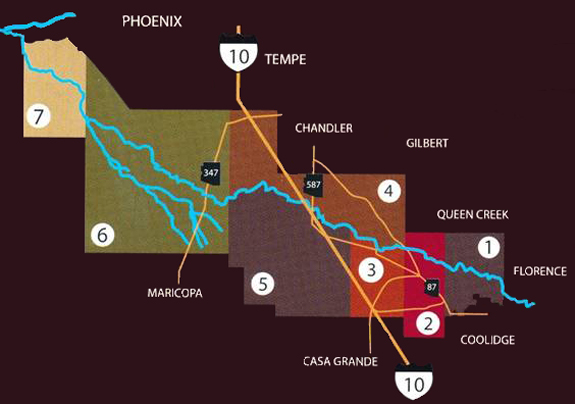
District 1- Blackwater - is the smallest and most Eastern district. It is roughly 50 square miles and is home to an estimated 1,160 residents in approximately 340 households. On October 2, 2013, residential curbside recycling service began in District 1. Abandoned and inoperable vehicles (along with scrap metals) do not pose a problem within the Community as individuals typically salvage them. Out-of-service buildings are a concern in several districts because there is a lag in addressing the demolition of these structures, as they require testing for lead and asbestos, which must be coordinated with OSHA and the Department of Public Works (DPW). DEQ receives and reviews the test results prior to demolition.
The Blackwater Industrial Park, located within District 1, currently has no tenants. A Phase I assessment has been completed at the site and only one area—an old burn pit—was detected to contain ammonium chloride. In 1997, a large tire fire occurred in this industrial park. Approximately 2 million shredded tires burned for several months in the fall of 1997. Environmental issues facing District 1: residential waste management, out-of-service buildings, recycling, Brownfields, and hazardous waste management.
District 2 - Hashen Kehk - is home to the Olberg Bridge, which stands as a reminder of the history and culture of the Akimel O’odham and Pee Posh tribes. It was once considered a great engineering wonder when it was completed in the 1920’s along with the Sacaton Dam—which diverted water to irrigate land in the district—as part of the Pima-Maricopa Irrigation Project. Water and farming have long been a tradition and a central part of life for the people of Hashen Kehk. In 2013, surface water was released in District 2’s reach of the Gila River as part of a groundwater recharge and ecosystem restoration project. This district is the smallest district—primarily residential with an estimated population of 530 and about 170 homes—and was the second district to receive curbside recycling services (initiated in February 2012). Environmental issues facing District 2: residential waste management, recycling, out-of-service buildings, water quality management—surface and groundwater, Brownfields, and wildlife and habitat management.
District 3 - Sacaton - was named after the giant Sacaton grass that once grew in this valley. It is one of the smaller districts of approximately 39 square miles, but the most populated district with an estimated residential population of 3,030 and about 630 households. District 3 was the first district to receive curbside recycling services (initiated in May 2011). Sacaton is the unofficial capital of the Community, as it has always been the center of commerce and government activity for the tribe—most government buildings are located in this district. Some agricultural activities (Gila River Farms & lease-hold farms) take place in this district. The Department of Public Works maintains a Solid Waste Transfer Station in District 3, which serves as a collection area for green wastes and has a shredder on site. Environmental issues facing District 3: residential waste management, recycling, out-of-service buildings, green wastes, Brownfields, universal wastes, air quality, pesticides, and agricultural wastes.
District 4 - San Tan - is large—119 square miles—and unique in that it is comprised of eight (8) distinct villages—with approximately 2,250 residents in about 530 homes—and has the Santan mountain range as its northeastern boundary. On October 2, 2013, residential curbside recycling services began in District 4. Because of its close proximity to the Phoenix metropolitan area and access from Interstate-10, District 4 has seen the most industrial growth of any of the districts—containing sports and recreation venues and tribal, commercial, and agricultural businesses, including hotels and casinos.
There are two industrial parks located within this district: 1) Santan with two (2) tenants and 2) Lone Butte Industrial Park with fifty-two (52) tenants. All tenants are permitted with several designated Hazardous Waste Generators—both small and large generators—that are inspected regularly for proper handling of wastes and hazardous material. The Santan Park contains a Brownfields site—a former tannery—that has been cleaned up and is currently undergoing the final reporting phase. Two (2) sand and gravel operations are located within this district and are inspected for proper waste disposal.
Another environmental concern that is unique to GRIC within this district and District 5 is the impact from smuggling immigrants from Mexico. GRIC is directly located between the Phoenix Metropolitan area and the Mexican border. Human smugglers have established staging areas within the Community prior to delivering their human cargo into the Phoenix area. These staging areas are indiscriminant spots in close proximity to Interstate-10 and are well concealed. The staging areas are littered with solid waste, as well as human waste. Mobile drug labs also pose a threat to the Community as they are left behind in random areas of the Community. Environmental issues facing District 4: residential waste management, recycling, water quality management—surface and groundwater, industrial waste management, hazardous waste management, underground storage tanks, Brownfields, air quality, pesticides, illegal dumping, agricultural wastes, and wildlife and habitat management.
District 5 - Casa Blanca - is roughly 99 square miles and is comprised of six village areas—with nearly 2,200 residents in about 500 households. Its northern boundary is the Gila River, which has made this district historically and presently the center of agricultural production for the Pima and Maricopa tribes. Today, modern versions of the ancient irrigation systems allow the Gila River Farms, founded in the 1960’s, to cultivate nearly 40,000 acres of land with approximately130, 000 acres of additional agricultural land available. Environmental issues facing District 5: water quality management—surface and groundwater, pesticides, air quality, residential waste management, recycling, illegal dumping, Brownfields, agricultural wastes, air quality, and wildlife and habitat management.
District 6 - Laveen - sits in the shadows of the Sierra Estrella Mountains where the sandy river beds of the Gila and Santa Cruz Rivers cross. District 6 is 176 square miles and has four village areas—with approximately 2,310 residents in about 540 homes, the Komatke Community Health Center, and one of the three Community casinos. Gila Crossings School, located in this district, has a Community garden with a demonstration composting area. Environmental issues facing District 6: residential waste management, recycling, green wastes, illegal dumpling, pesticides, Brownfields, agricultural wastes, water quality management—surface and groundwater, air quality, wildlife & habitat management.
District 7 - Maricopa - is the western most part of the Community at the base of the Sierra Estrella Mountains. The Gila River joins the Salt River at the District’s northwest boundary creating two lush wetlands—diverse ecological habitats in the desert region. District 7 has an estimated population of 660 and the fewest homes (about 160). Due to the location of District 7—proximity to the Phoenix metropolitan area and the Salt River—it provides illegal dumpers the opportunity to trespass, thus making illegal dumping a concern in this district. Environmental issues facing District 7: residential waste management, recycling, illegal dumpling, agricultural wastes, water quality management—surface, aquatic habitat, and groundwater—pesticides, air quality, and wildlife and habitat management.